Friday, April 30, 2010


The clay model represents all the Starbucks outlets in greater London - with a massive concentration in the West End and City.

The second two maps (TOP) are extentions of the layers idea I sketched. This denotes Starbucks concentration (judged us undesirable by my interviewees), all-night eating places (desirable) and football stadiums (favourite places).

After showing my prototypes it was thought I might want to continue the 3D theme. I was encouraged to research the visual language of maps and consider materials. Reappropriated objects for example, like Starbucks cups. The content could be flexible as the format was starting to be explored, as per the brief.


After ideas generation and concept challenge workshops I started to think about how to represent some of the more interesting answers I found, such as people's likes/ dislikes and favourite places. The original long questionnaire was sidelined as it seemed like I knew what the political map stuff would look like already and I needed to explore much more.


Temple: Location for 'Great Expectations'.

I went to the various places mentioned in people's fictional stories and questioned a few more people. The interviewee in Temple described his favourite London walk to Pall Mall and 'Old London'.


Heygate Estate: The setting for Michael Caine 'Harry Brown' film.


Fitzrovia: Location for Ian McEwan's 'Saturday'.


I thought that the way I would procede for further research was to go to the places where people's favourite fictional London stories were located, and to explore any links between them.


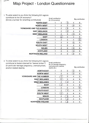
Some of the qualitative answers I got when testing my questionnaire were really interesting. Asking people to draw a doodle of their perfect image of London yielded some great images. Also people I asked specified what their favourite stories set in London were, where their favourite place was and what type of places we need more/ less of.

Thursday, April 29, 2010

Click here to take survey

On the basis of the skewed US Map, I thought it might be interesting to make a london-centric map of the UK. Distorting size and shape of UK areas according to the answers londoners gave. I prepared a questionnaire on survey monkey but tested it out on a few people beforehand...

Friday, April 23, 2010


This video in decode exhibition shows daily flights in real time across the globe. Inspires idea of doing an animation, possibly of the progress of fictional characters over a timescale. I would like to show the progression of materials too, perhaps from the primitive, through print to digital. First i need to think more creatively about a solution however, applying design thinking. I should consider wayfinding, navigability, what's the map for? i.e. much of the concept challenge and stepping stones exercises discussed in college.

Thinking about materials for more tactile maps, rather than just the 2D print stuff. Materials can suggest different things. Stones can be primitive looking, plastic represents urban spaces, moss growth and the drying grass erosion and decline.


Was looking at an article in Grafik where a designer said he got inspiration looking at a shower head, with it's concentric circles for some information design. I looked at my desk and saw a spiral from a bit of a car I found - what could this represent - growth I thought. This shell kind of spiral graphic appears a lot in maps and info graphics.
Here is an example showing literary stories and how fictional characters intersect on their travels, hard to see here but there is Pygmalion and Leviathan here and others. I think because there are many examples of maps showing heaven and utopia that fictional characters in maps is a similar thought. This is part of exploring the idea that maps can perhaps never be truly factual.


I started thinking about political ideology, how information and stats are represented. The US map here is interesting and skewed by population size on the right. There is another thought for materials here too.
MAPS
My chosen format maps - the VCT talk made me think about ideology. Here is an installation of Russia, America and Europe on different 'mental' levels, (according to the book I was reading.)

Followers